Connecticut River

Historic Columbia Covered Bridge (New Hampshire) by Todd Henson

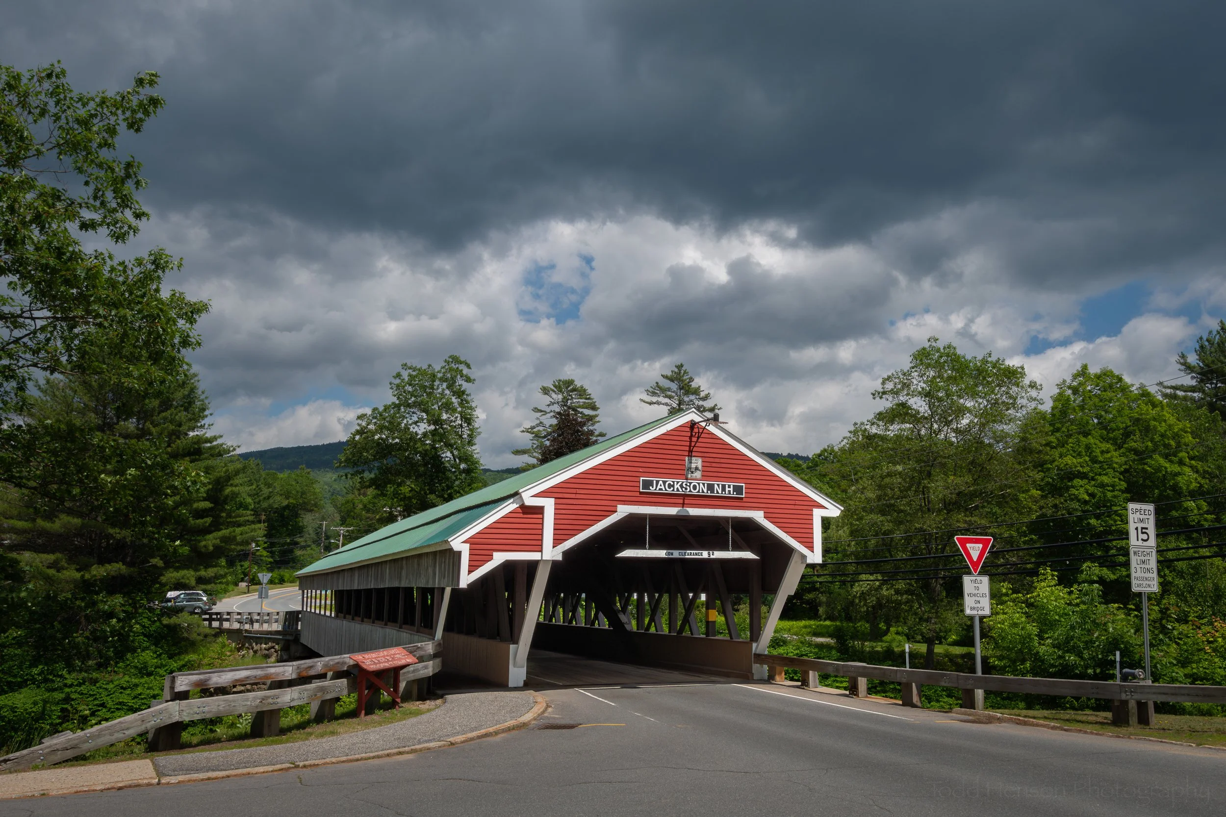
Facing the Columbia Covered Bridge from the New Hampshire side.

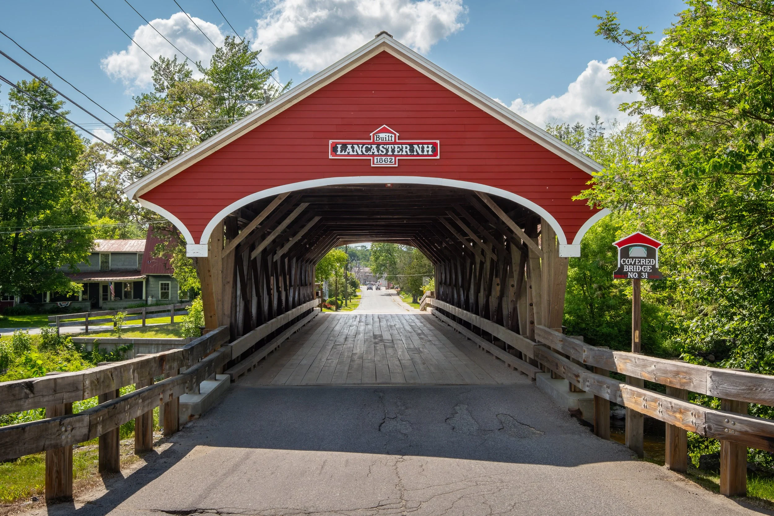
The Columbia Bridge spans the Connecticut River, connecting the town of Columbia, New Hampshire, to that of Lemington, Vermont. As is so often the case, this was not the first bridge at or near this location, with multiple instances before that were destroyed by floods, wind or fire. All the previous incarnations had been toll bridges, with folks who frequently had to cross the river purchasing annual subscriptions to assure they could purchase groceries or board the train on the New Hampshire side. The first bridge was built around 1820, and the current bridge was constructed in 1912.

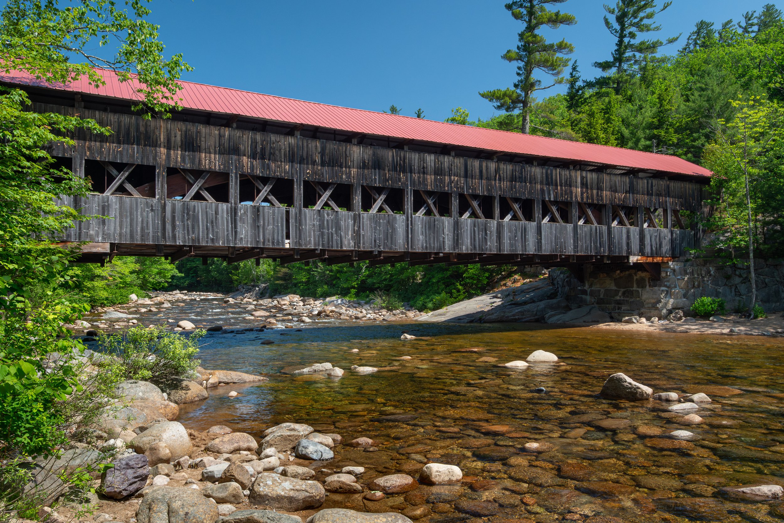
An angled view of the Columbia Covered Bridge in New Hampshire, with the Connecticut River below.

The Columbia Covered Bridge as seen from the New Hampshire shore of the Connecticut River.

Columbia Bridge is a single-span bridge built using the Howe truss design based on the 1840 patent by William Howe. This design features metal vertical supports to provide extra support beyond what wooden supports could provide. As with other bridges that span between states there were sometimes disagreements about which side would provide funding for construction and/or repairs. And both towns are small enough they did seek funding from their respective states as well as other organizations and the federal government.

A view of the Connecticut River from below the Columbia Covered Bridge.

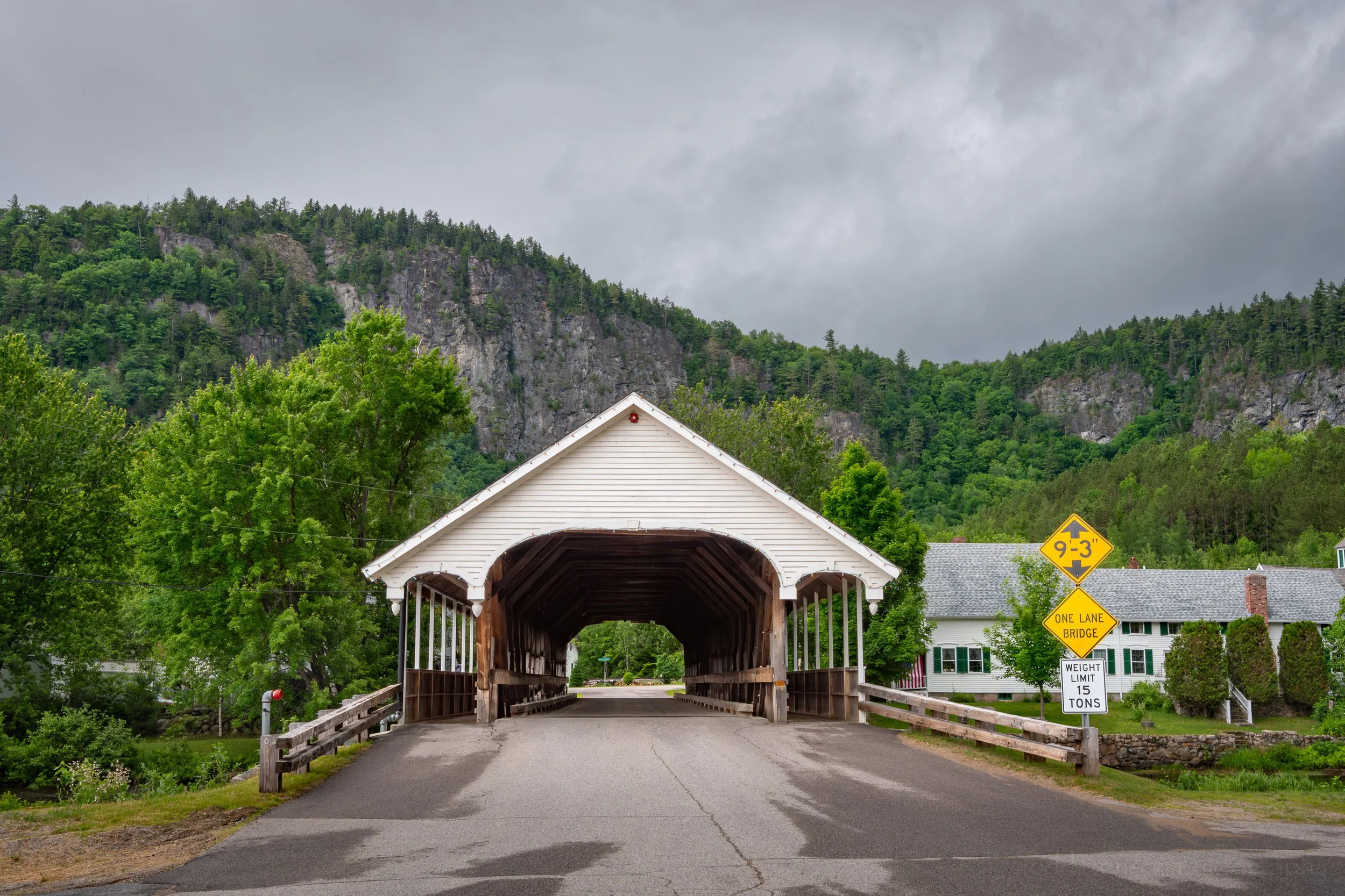
The Columbia Covered Bridge as seen from Vermont.

Columbia Covered Bridge is number 33 in the New Hampshire list of covered bridges. We visited this bridge on June 20th, 2025. Click here to see the list of covered bridges we visited while traveling through New Hampshire in mid-2025.

Resources

Most of the details within this post were learned either from signs at the bridge or from the fantastic book, Covered Bridges of New Hampshire by Kim Varney Chandler, which I purchased from a small local shop in Lincoln while on our trip. It’s well worth it if you plan to visit the area or are just interested in covered bridges and their history and construction. The link takes you to the author’s website for the book with lots of extra information and with links to let you purchase directly from her.


Do you enjoy these posts?

Sign up to receive periodic emails with updates and thoughts. Don’t worry, I won’t spam you. And please consider purchasing artwork or products from my online store, and using my affiliate links in the sidebar to the right when shopping online.

I appreciate your support!


Historic Mount Orne Covered Bridge (Lancaster, New Hampshire) by Todd Henson

A vehicle drives from New Hampshire towards us, in Vermont, through the Mount Orne Covered Bridge.

The Historic Mount Orne Covered Bridge, named for the nearby Orne Mountain, spans the Connecticut River and connects Lancaster, New Hampshire, to Lunenburg, Vermont. It was built in 1911, though an earlier bridge, called the South Lancaster Bridge, was built at the location likely between 1870 and 1885. It is more of a utilitarian bridge than some others with less in the way of aesthetic design and has been a key crossing point for many years for some industries.

A view of the Mount Orne Covered Bridge as seen from the Vermont shore of the Connecticut River. Look closely and you may see a fisherman on the far side under the bridge.

A view of the Connecticut River from the Vermont side, near the Mount Orne Covered Bridge.

Mount Orne Bridge is an example of a Howe truss, patented by William Howe in 1840. In this design, vertical supports are metal rods instead of timber, which increased the load capacity of the bridge. This is one of four Howe truss bridges in New Hampshire. It is a two span bridge with a length of 266 feet. At one point maintenance was equally shared between New Hampshire and Vermont, but when the boundary between states was moved to the Vermont side of the river New Hampshire took on the majority of costs with Vermont just maintaining the entrance and a small section on their end.

A view inside the Mount Orne Covered Bridge. Notice the vertical metal support rods indicative of the Howe truss design.

Driving through the Mount Orne Covered Bridge towards New Hampshire.

Being a utilitarian bridge, Mount Orne Bridge has been used by many trucks transporting materials across the bridge. Unfortunately, it has also been victim to many accidents with loads that were too tall, tearing up the roofing beams and supports, or too heavy, causing damage to the flooring. The sign above the entrance has the dates of 1911, the original construction date, and 1983, when major revocations occurred. But due to all the accidents it has undergone many repairs over the years. During some years signs were posted to cross at your own risk. And at other times the bridge was completely closed.

Exiting the Mount Orne Covered Bridge into New Hampshire and the rain.

Mount Orne Covered Bridge is number 30 in the New Hampshire list of covered bridges. We visited this bridge on June 19th, 2025. It began to sprinkle while we were on the Vermont side, and while we drove through the bridge towards the New Hampshire side the rain increased. Click here to see the list of covered bridges we visited while traveling through New Hampshire in mid-2025.

Resources

Most of the details within this post were learned either from signs at the bridge or from the fantastic book, Covered Bridges of New Hampshire by Kim Varney Chandler, which I purchased from a small local shop in Lincoln while on our trip. It’s well worth it if you plan to visit the area or are just interested in covered bridges and their history and construction. The link takes you to the author’s website for the book with lots of extra information and with links to let you purchase directly from her.


Do you enjoy these posts?

Sign up to receive periodic emails with updates and thoughts. Don’t worry, I won’t spam you. And please consider purchasing artwork or products from my online store, and using my affiliate links in the sidebar to the right when shopping online.

I appreciate your support!


Historic Haverhill-Bath Covered Bridge (New Hampshire) by Todd Henson

The Haverhill-Bath Covered Bridge

The signs above the Haverhill-Bath Covered Bridge in New Hampshire show the year 1827, which is the year the bridge was planned. It wasn’t actually completed until 1829. Even so, it is the oldest covered bridge in New Hampshire and one of the oldest in North America. Unlike many other covered bridges, it’s the first and only bridge at this location, as stated on a sign inside the bridge.

The Haverhill-Bath Covered Bridge as seen from the Raymond S. Burton Bridge. In this wide view I wanted to include as much as possible so I stitched multiple wide angle photos into this panoramic image and there is a little distortion with the bridge appearing bowed in the middle, which it is not.

A view of the two-span Haverhill-Bath Covered Bridge

A path leads down to the rocks and the river with the dam and hydroelectric plant on the Woodsville side

The Haverhill-Bath Covered Bridge is a two-span Town lattice truss, following the patent of Ithiel Town. It is the oldest Town lattice truss still in existence. It spans the Ammonoosuc River (Abenaki for “small, narrow fishing place”) just before that river flows into the Connecticut River at the village of Woodsville, part of the town of Haverhill, with the town of Bath on the other side of the Ammonoosuc.

Facing the Haverhill-Bath Covered Bridge, about to walk back across to the parking lot a little ways beyond

Walking through the Haverhill-Bath Covered Bridge showing some of the lattice structure inside

Another view inside the Haverhill-Bath Covered Bridge, showing the arches installed for extra support

Looking out from the Haverhill-Bath Covered Bridge at the calm Ammonoosuc River above the dam

An interior detail view of some of the support structures showing both Town lattice truss and arches

The passing of time can be hard on wooden covered bridges, especially when they were only designed to carry the weight of a horse and buggy. Instead of replacing the bridge the two towns decided to reinforce it, adding arches between 1921-1922. They also added the pedestrian sidewalk, which I quite like as it completely separates pedestrians from automotive traffic. But by 1999 it was time to completely remove automotive traffic from the bridge, so the nearby Raymond S. Burton Bridge was constructed. Thankfully, the towns have continued to maintain the covered bridge and still allow pedestrians to cross, enjoying this piece of local history.

The pedestrian sidewalk inside the Haverhill-Bath Covered Bridge

Two bridges, the Haverhill-Bath Covered Bridge in the foreground and the Raymond S. Burton Bridge in the background.

Walking over the Raymond S. Burton Bridge with the Haverhill-Bath Covered Bridge just visible on the right.

The Haverhill-Bath Covered Bridge is number 27 in the New Hampshire list of covered bridges. We visited this bridge on June 19th and 25th, 2025. Click here to see the list of covered bridges we visited while traveling through New Hampshire in mid-2025.

Resources

Most of the details within this post were learned either from signs at the bridge or from the fantastic book, Covered Bridges of New Hampshire by Kim Varney Chandler, which I purchased from a small local shop in Lincoln while on our trip. It’s well worth it if you plan to visit the area or are just interested in covered bridges and their history and construction. The link takes you to the author’s website for the book with lots of extra information and with links to let you purchase directly from her.


Do you enjoy these posts?

Sign up to receive periodic emails with updates and thoughts. Don’t worry, I won’t spam you. And please consider purchasing artwork or products from my online store, and using my affiliate links in the sidebar to the right when shopping online.

I appreciate your support!